Victoria Falls National
Park, Zimbabwe
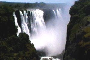 Located on the
Zambezi River, about 621 miles from its source, the Victoria Falls are Zimbabwe's best-known geographical feature and
tourist attraction. With a width of 5600 feet and an average
depth of about 328 feet, they form the biggest single curtain of
falling water in the world.
Located on the
Zambezi River, about 621 miles from its source, the Victoria Falls are Zimbabwe's best-known geographical feature and
tourist attraction. With a width of 5600 feet and an average
depth of about 328 feet, they form the biggest single curtain of
falling water in the world.
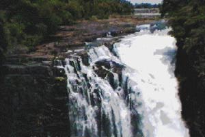
The flow of water over the Falls varies
according to the time of year and the rainfall in the Zambezi's
upper catchment areas in western Zambia and Angola. In November
and December it may be only 706 000 cu feet per minute but
towards the end of a normal rainy season it reaches 17 650 000 cu
feet or more per minute. During the record- breaking floods of
1958 it reached a peak of 24 710 000 cu feet per minute. The
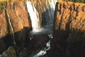
Falls take the form of a sheer-sided chasm, as little as 197 feet
wide in places, running almost at a right angle across the river
width. The southern lip of the gorge creates a natural viewing
platform from which the full extent of the Falls can be seen at
close quarters.
Formation
Some 19th century European explorers of
central Africa, such as David Livingstone, believed that the
Falls were created by a cataclysmic rifting of the earth's crust
but geologists who later visited the area realised that the Falls
and the gorges downstream had been cut by the erosive power of
the river.
Until the beginning of the Pliocene era,
about 11 million years ago, today's upper Zambezi may have flowed
southwards to join the Orange River in South Africa;
subsequently, a gentle upwarping across the river's course may
have caused its waters to form an inland sea in northern
Botswana.
These waters later spilt eastwards across a
depression in a basalt slab which had been pushed up to the
earth's surface during the Upper Karoo era, some 150 million
years ago, and which had become covered in sediments. The newly
aligned river removed these sediments and began to cut back
through the basalt, creating the Batoka Gorge.
However, near the Falls themselves, the
basalt is criss-crossed by traverse faults; the softer material
that filled these faults was excavated by the river, creating a
succession of waterfalls. The Victoria Falls represent the latest
in this series of faults and are cutting back at their western
end, at Devil's Cataract, into another fault that will form the
Victoria Falls of the future.
 Peoples
The gravels in the area form one of
southern Africa's richest archaeological sites; within them have
been found implements ranging from pebble tools to the delicate
microlithic artifacts of the Late Stone Age.
By the mid-19th century, the area was
occupied by the Makololo, a Sotho group who had migrated from the
Transvaal and who for a brief time dominated the other people
living in the area, the Leyas, Lozi, Tokas and Subiyas.
The Makololo called the Falls Mosi oa
Tunya, meaning 'the smoke that thunders'; however, when
Livingstone arrived at the Falls he renamed them after the
reigning queen of the British Isles, Victoria.
 Conservation
Since the completion of the Victoria Falls
Bridge in 1905 the history of the Victoria Falls has been one of
the development of tourism. The area has successfully avoided the
excesses that have marred similar scenic tourist attractions
elsewhere in the world.
On the Zimbabwean side, the only evidence
of human intervention is the network of paths and viewpoints
sited within the Rain Forest on the lip of the gorge opposite the
Falls.
The Rain Forest, despite its popular name,
is not a true rain forest; it is really only an unusually dense
and extensive piece of riverine forest and is composed mainly of
the ebony, fig and mahogany trees common to most riverine
woodlands in Zimbabwe.
However, it does contain several rare
herbaceous species; one species, a fern, Cheilanthes farinosa, is
found nowhere else in the world apart from in two localities in
Zambia. The forest is inhabited by some smaller mammals,
including warthog, vervet monkeys and bushbuck. Within the gorges
are many raptors, notably the black eagle and the Taita falcon.
The Victoria Falls are part of the 5 782
acres Victoria Falls National Park. Because of their unique
scenery and geological interest the Falls have been designated a
World Heritage Site under the UNESCO World Heritage Convention,
to which Zimbabwe is a signatory nation.